Monday, June 30, 2014

JMT Training: Peak 5 (+2) of 21: West Osceola (+ Middle Osceola and Osceola). June 29, 2014

Mt. Osceola Trail, bushwhack.  About 8.4 miles with around 2300 feet of elevation gain.

West Osceola is on the Trailwrights list, which Alex and I hope to finish soon after we return from the John Muir Trail.  We hope to get all but two of her remaining peaks before we leave.  This is ambitious, and I'm not sure it can be done, but we'll have fun trying.  We're also trying to finish up Sage's 52WAV list...we'll see what happens.  At the latest, both girls should finish their lists before the end of September.

I didn't count Middle Osceola and Osceola as part of the 21 peaks we're trying to bag before the end of July, but I'll certainly count them if we fall a bit short of our intended goal.  :)

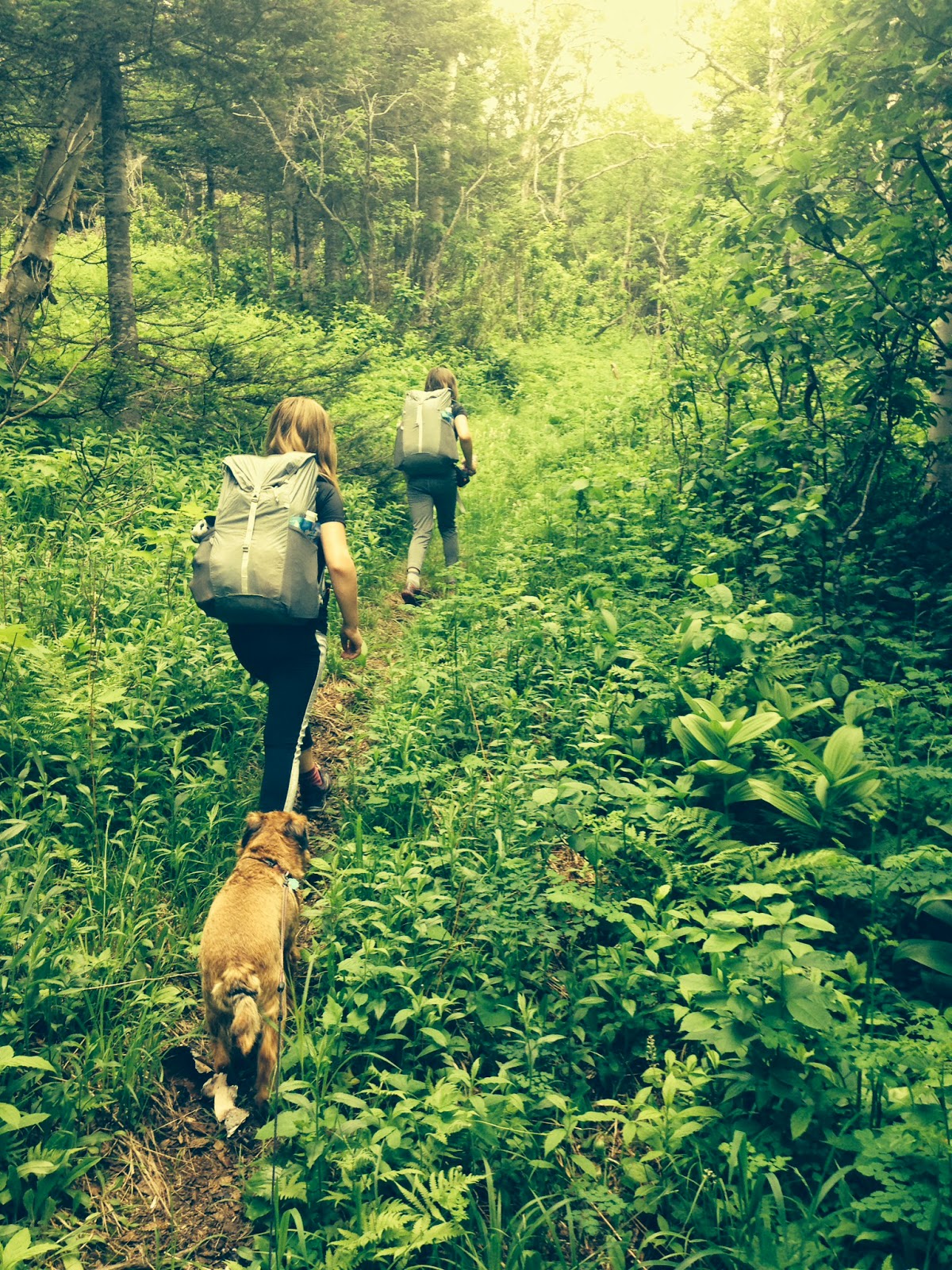
We awoke early Sunday morning and hit the trail at 5:30.  We wanted to a) beat the heat that was in the midday forecast and b) beat the crowds.  We try to stay off popular trails on weekends during peak hiker-season.  We enjoy the company of others, but it's nice to have a mountain to yourself.  Our early start gave us the trail to ourselves during our ascent.

I won't bother with the photos of Mt. Osceola Trail, since you can find plenty of those in my earlier trip reports (here, here, and here) or on other hikers' blogs.  Instead, I'll start with the turn off of Mt. Osceola Trail onto the bushwhack.

The herd path begins at the last switchback on the way up, one or two tenths of a mile from the summit.  Ascending, the path turns left off the trail...the girls point the way in the photo below.


Note the small rectangular stone at the entrance, to the left of the herd path.  When you're looking directly at the herd path from the trail,  this is what you will see...


The herd path is well defined for a tenth of a mile or so...


...and then, not long after passing a boulder (glacial erratic), you run into a thick jumble of blowdowns.  We headed to the right around the blowdowns, then we (sometimes) followed old herd paths and (often) climbed over, through, and under trees, branches, and logs.  It's a ridgewalk, so it's difficult to get lost since you can see where the slopes on either side of you begin to steeply descend.  Stay on the ridge and keep plowing along, and you'll get to Middle Osceola.

The photos below somewhat document our 'whack to Middle (which we've visited before).


This dirt/rock scramble was over my head and
 those trees are not firmly rooted.  Fun!

The girls enjoyed climbing through everything.

View through the trees


Little viewpoint not far from Middle Osceola's summit


We reached Middle Osceola's summit and once again found no evidence of a canister.  We took a short water break, then plunged downward into the col between Middle and West Osceola.

Though we hadn't before visited this section of woods, the route finding was easy.  Both sides of the ridge are almost always a short distance away, so it's easy to stay on top...just not-so-easy to fight your way through the thick bunches of branches/logs/trunks.  There are old herd paths here and there, and sometimes the woods open up a bit, but blowdowns and overgrowth a-plenty are here, there, and everywhere.


Still smiling

As you near West Osceola, stay close to the left (south/western) section of the ridge.  You will run right into the cliffs...follow the faint herd path to the right -- that quickly turns back to the left and becomes more obvious.  It will go straight up, steeply, with a view of Middle Osceola to your left and through the trees...


until you reach the bottom of Peggy's Perch.


Climb up...but have a care, those trees on the left of the climb are not firmly rooted!  Once up, sit and take in the views (the herd path continues to the left of Sage in the photo below, at the top of Peggy's Perch).


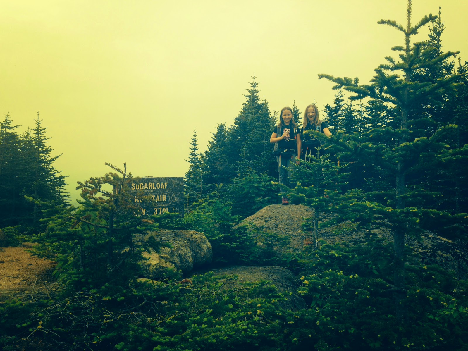
Peggy's Perch is a short distance away from the summit.

West Osceola!

Congratulations on another Trailwrights peak, Alex!
 Seven more to go!

It was 8:45 am when we reached West Osceola.  We were grateful for our early start, because we could already feel the day getting warm and we would not have wanted to ascend Mt. Osceola Trail in 80+ degree weather.

The girls and I made our way back to the maintained trail and jogged up to the main summit, to see if we might still beat the weekend crowds to the main peak.  Almost, but not quite...a group of four men were standing on the peak admiring the views.  I recognized one of the men as Marty, whom I've run into a few times on the trails.  He's a kind fellow and it was nice to see him again.  The others introduced themselves and we exchanged pleasantries, then the gentlemen left for East Osceola and we had the summit ledges to ourselves for a bit.

Main summit ledges.

Alex naps while Sage has a "negative outcome."

We left the summit area at 10:30 and began the descent.  The parade of hikers and dogs began not long afterward...every five minutes, we'd pass a couple or a group, most of them with dogs.  ALL the dogs were extremely well-behaved and ALL the people were joyful and smiling.  It was nice, I enjoyed it...I usually steer clear of crowds, but yesterday's descent was extremely enjoyable.  Perhaps I've allowed myself to become too much of a hermit lately.  Lots of people on the trails can be fun.


We made it back to the car around 12:30.  The heat was becoming intense and all three of us were VERY glad we'd had an early start.

NOTE -- we wisely did NOT bring our JMT packs on this hike.  They would have been torn to shreds.  We used our old packs and wore old clothes.

Here's some visual documentation of our bushwhacking wounds...struggling through/over/under/around sharp branches can be bad for your skin (and clothing!)...

My shirt


Sage's leg
Sage's arm
my arm

my leg

Alex's arm

We were going to do an overnight tonight, but we had to stay home today due to last-minute errands.  Instead, we're hiking early tomorrow morning and all day Wednesday.  I should have those two trip reports up by late Thursday evening.

Peace.

Wednesday, June 25, 2014

JMT Training Hike, Peak 4 of 21: Mt. Sugarloaf (Groveton, 52WAV). June 24, 2014

Don't forget, folks -- we're fundraising for Feeding America, and we've still got a few hundred dollars to raise, so if you can afford to donate, please do!  Thanks!  We've only five weeks until the John Muir Trail, and we'd love to meet our fundraising goal before we leave New Hampshire.

Mt. Sugarloaf in Groveton via Mt. Sugarloaf Trail.  4.2 miles roundtrip with 2200 feet of elevation gain.

Though the views from the summit ledges are lovely, I don't think I'll ever do this one again.  The trailhead is far, far, north along a bumpy forest service road and the trail feels like an unrelenting slog straight uphill.

I'm happy to report that we made short work of this unremarkable trail -- we were up and down in two and a half hours (including snack time on the summit), which is far less than adult book time.  The girls have been hiking faster than adult book time for a while now, but I'm still surprised when we finish earlier than I expect.  As has happened on previous hikes, they had to stop and wait for me on some of the steeper bits as I huffed and puffed my way up.  They're carrying everything they'll carry on the JMT now, so their speed and stamina are good signs of their ability to handle and enjoy our upcoming thru-hike.

The trail begins by a cabin along Nash Stream Road, a little over eight miles north of Emerson Road in Groveton.


The trail goes to the left of the cabin and around a gate...


...before heading into the woods. A tenth of a mile in, there's a sign at an intersection.  Take the left for the Cohos Trail and the right for Sugarloaf Mountain.


The trail then looks like this (but much steeper) all the way up to the remains of the fire warden's cabin at 1.6 miles.


The trail levels off a bit just before reaching the clearing with the cabin.


The cabin is in poor condition...


From here, the trail heads back into the woods...


and ascends another half a mile (sometimes steeply) to the summit ledges.


Summit!


Our views were one-directional.  The day was warm and humid, as you can probably tell from the haze.


This was a nice exercise hike, but I'm glad we've crossed it off Sage's 52WAV list.  It's not my favorite peak in the world.  I don't mind straight-up slogging if there's water to cross or interesting boulders to see, but this trail felt rather bland.  It's well-maintained, though, so folks looking to bag this peak shouldn't have any trouble doing so (thanks, trail workers!).

Alex and Sage returned from this hike and went to karate class for two hours, where they earned new belts (congrats, girls!).

Our next hike was supposed to be today -- right now, actually -- but the forecast calls for major thunderstorms and heavy rains all over the Whites, so we must postpone today's adventure.  We're on a tight schedule, so we may have to use of the girls' karate days to fit in all the peaks we want to do before we leave.  I'd like to not let that happen, though, since Alex and Sage love karate and their classes are important to them...this summer is a whirlwind of juggling between homeschooling and hiking and karate and playdates and camp and outings with the girls' clubs....it's difficult to make up hiking days.  Still, better to figure it out than to go today and get struck by lightning.

Our next hike is Sunday.  We may do an overnight, so I might not write another trip report until late Monday evening.

Have a good weekend, folks!

Monday, June 23, 2014

JMT Training, Peak 3 of 21: Mt. Success (52WAV)...and the site of the plane crash. June 22, 2014

Mt. Success Trail, Mahoosuc Trail, herd path, Outlook Trail.  About 8 miles roundtrip with about 2000 feet of elevation gain.

We haven't hiked on a Sunday in a long while.  I prefer to hike during the week, when the summits are relatively free of people.  I'm not antisocial, and other hikers are cool and what-not...but when I go into the woods and up a peak, I don't want to hear a constant string of voices or share the summit with large crowds.  This is one reason I do not enjoy hiking in large groups (unless it's a specific, celebratory hike -- in those cases, the more the merrier).  One or two other trekkers (besides my kids) works well...any more than that, and I no longer feel I'm in the wilderness.

Our way to avoid the crowds is to stay off the 4Ks on bluebird weekends -- therefore, last Sunday, in perfect above-treeline weather, we chose to hike Mt. Success.  Mt. Success is on the 52WAV list, and it's located along the Mahoosuc Range.  This turned out to be the perfect choice.  We had the summit all to ourselves...we saw only two small groups of people, and we saw them while we were descending.  Guess everyone else was on the Presidentials.  The Appalachia parking lot, which we drove past on the way to Success Pond Road, was overflowing with cars up and down the street at 7am.  The little grassy lot along Success Trail, in contrast, was nice and empty when we arrived.

Success Trail is right off of Success Pond Road.  One can drive along the trail (high-clearance vehicles only!) for a few tenths of a mile before reaching a large, grassy field.  We parked in the field, then headed into the woods at the far right-hand side of the clearing.


After about a mile, we reached the bottom of a short series of steepness....


Near the top of the steep bits, a few tenths of a mile below the intersection with Mahoosuc Trail, we passed the Outlook Trail (more on that later).

Here we are, at the intersection with Mahoosuc Trail...


From here, the going was easier.  Just a half mile up a relatively flat bit of trail.


One more steep, but very short, section, and we were on the summit.


Congrats on another 52WAV peak, Sage!


We took a short snack break and admired the views.


We then visited the crash site.

There are more than a few excellent write-ups regarding the crash of 1954, so I won't attempt to reinvent the wheel.  Instead, I'll direct you here for the details.

Though I easily found directions to the crash site by doing a few Google searches, I'm hesitant to describe the herd path on my blog.  Hypocritical, I know, but I feel strange advertising a place where two people lost their lives.  You'll find your way to the crash site easily enough by reading the trip reports of others...it shouldn't take you more than thirty seconds of web surfing....and, once you're out there and on the right path, the way is obvious.

Flight 792

The girls pay their respects.

We solemnly made our way back to the summit...


...and took a rest.


After some more snacking, we made our way toward the car.  Before finishing our hike, we took the Outlook Trail detour...and oh my goodness, am I glad we did.


This view was far better than what we'd experienced at the summit.  Gorgeous gorgeous gorgeous.  We lounged here for a while before descending.

This was a fantastic hike in perfect weather.  We'll hike again tomorrow, though I believe we're in for some fog and rain.  Oh well, we've had an excellent run of it in terms of sun and views, so I suppose we're due for some clouds and drizzle.  This is, after all, New Hampshire.

Some notes -- the girls are now carrying everything they'll carry on the JMT.  Their pack weight, without water, is six pounds. That includes a sleeping bag, sleeping pad, changes of clothes, one day's worth of food, rain gear, fleece, headlamps, an emergency bivy, and duct tape.  With water, and if they carry a bit more food, their pack weight will be eight or nine pounds.  Hooray for ultralight equipment!

I'm now carrying everything I will usually carry...though there will be two stretches where I'll carry significantly more food.  Every time we go out on a training hike, I add food to my bear canister.  Right now, I'm up to a total pack weight of 20 pounds.  That includes a sleeping bag, a three-person tent, two sleeping pads, a bear canister, 10 pounds of food, changes of clothes, rain gear, fleece, a headlamp, a pocketknife, duct tape, a small gear repair kit, and a few first aid supplies.  At the heaviest (because of multiple days of food supplies), my pack will weigh 35 pounds.  Usually, it'll weigh 27-28 pounds.  Again, hooray hooray hooray for ultralight equipment!

The girls are doing well with the multiple-times-a-week hiking routine.  Of course, we're about to kick up the mileage and elevation gain...and they're also continuing their karate class through the summer...so we'll see how it goes.

I will continue to blog about each training hike as we do them, but sometimes the entries will be short.  We homeschool a bit through the summer (math, foreign languages, writing, reading, and typing), and the girls have planned activities, camp, and playdates, so the hours fly by and I find myself with very little time at the end of each day.  However, I enjoy recording our process...and we want to reach our fundraising goal for Feeding America!  The trip reports will therefore be posted, but they might feel skimpy from time to time.

'Til tomorrow evening...