Showing posts with label T25. Show all posts

Friday, June 20, 2014

JMT Training, Peak 2 of 21: North Percy Peak (52WAV and T25).

All I can say about North Percy is...wow.  This is now, by far, my favorite peak in New Hampshire when it comes to views.

North Percy Peak via Percy Peaks Trail, Percy Loop Trail, and a roadwalk.  Six mile loop hike with about 2150 feet of elevation gain.

Sage and I used our new ultralight Gossamer Gear backpacks today.  Alex's backpack had not yet arrived, so she brought her old, trustworthy (but not ultralight) Osprey 25 on this hike.  Sage carried her new ultralight sleeping bag, a change of clothes, water, and one day's worth of food in her new backpack.  Her pack weighed less than Alex's...and Alex carried only a change of clothes, water, and half a day's worth of food.  My backpack held my new ultralight bear canister, 6 pounds of food, our new ultralight three-person tent, two sleeping pads, a change of clothes, and two liters of water.  All of that weighed far less than what I carried on the Camino last year.  Of course, I'll be schlepping a lot more food and a bit more gear when we actually do the JMT, but still...gotta love going ultralight!  I'll do a full report on each item we use on the JMT after we return in September.

We arrived at the trailhead to find a friendly fellow named Creston gearing up.  Creston's a veteran NH hiker; we enjoyed speaking with him about various trails and peaks, and we enjoyed meeting his dog, Daisy.  The girls and I "played leapfrog" with Creston and Daisy throughout our hike, and we shared some summit time with them on the peak.  It was a pleasure meeting them both.

At the trailhead...


Heading into and through the woods (the grades were usually moderate)...


Love the tree on this boulder!

We hit the base of a wet ledgy area at about 1.2 miles...


The trail went steeply up, to the right of the wet ledgy area...


...then it crossed a few slanted, dry ledges...


...before heading back into the woods.  The path flattened out a bit for the last couple tenths of a mile before the intersection with Percy Loop Trail.


From here, it was a steep half mile up to the peak of North Percy.


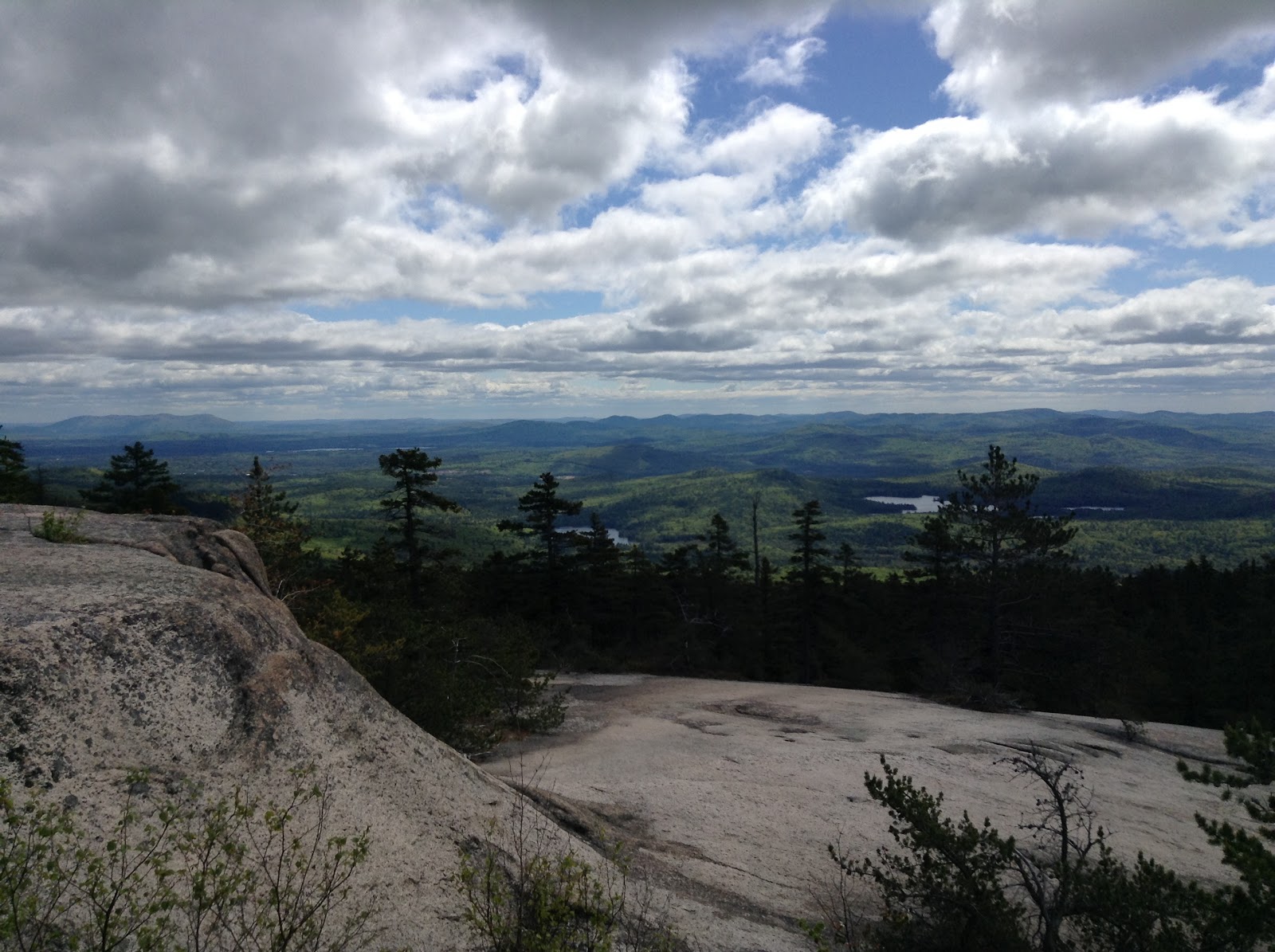
Breaking out above treeline was glorious...the weather was perfect and the ledges were easy to climb...and oh my goodness, the views views views views views!

These ledges are what qualify this hike for the T25 list...
this trek is fine in good weather, but I'd hesitate to try it during rain or in the winter)

We'd take a break from ascending the ledges every few minutes to turn around and look at THIS --


We reached the summit (congrats on another 52WAV peak, Sage!)...


then we sat, ate, and enjoyed the incredible morning.

Eventually, we began heading back down.  The girls and I loved descended the ledges, since the views were simply fantastic.


After reaching the intersection, we decided to take the Percy Loop Trail and then roadwalk back to our car.  Percy Loop Trail was fairly easy to descend...it wasn't as steep as Percy Peaks Trail and the footing was relatively free of rocks and roots.


We made it to the road...


...and walked the mile or so back to the car.


What a wonderful morning!  Sage and I love our new packs!

Our first week of training is complete.  Next week, we'll kick it up a notch by hiking three times a week (two 52WAV hikes and one TW72 hike).  Alex will have her new pack, and each of us will carry a bit more weight.  Within two weeks, each of us will be carrying everything we'll carry on the JMT.

I must say, though...I don't know what the JMT has to offer that NH doesn't...today's scenery was so breathtakingly beautiful that I can't imagine a prettier view on earth.

Tuesday, June 11, 2013

Tuesday Trip Report: Magalloway Mountain. June 7, 2013

Today's trip report will be a short one -- be sure to come back first thing tomorrow morning, June 12, for my review of Dan Szczesny's inspirational memoir, The Adventures of Buffalo and Tough Cookie.

*****

Coot Trail, Bobcat Trail.  1.6 mile loop with 800 feet of elevation gain.

The forecast called for constant rain, so a Terrifying 25 trail was out of the question.  Instead, the girls and I opted to bop up Magalloway Mountain, a short and easy 52WAV peak. 

The girls and I piled into the car and headed north.  And north.  And north some more.  It took us three and a half hours to get to Magalloway Road, which is north of Pittsburgh, NH and just south of the Canadian border.  The girls carschooled until they ran out of assignments, then listened to Freakonomics podcasts until we finally arrived at the trailhead.

Parking lot and trailhead for Coot Trail...

 
 It may have been raining all day down in the Whites, but the sun prevailed up in North Country.  Though the clouds were thick and low, not one drop of water fell during our hike.
 
The Coot Trail was muddy and steep, but well maintained.  Our 0.8 mile ascent was straightforward and quick.


I hadn't told the girls about the fire tower on the summit; they were thrilled to see it when we reached the clearing.


Up we went...


Views all around...


The descent was tricky -- I had forgotten a map and the trails were not signed at the top.  I wanted to take Bobcat Trail down...Coot and Bobcat make a loop...but I couldn't immediately figure out which way to go.  There are a few herd paths descending from the summit, so Bobcat Trail is not obvious.  Finally, with the help of a compass, I figured it out.  Start out on Coot Trail, then take a wide path that branches to the left during the descent (not far from the summit).
 
At the end of Bobcat Trail, about 50 feet from the parking area....
 
 
Though I kvetched online about having to drive seven hours roundtrip for a 45 minute hike, I did enjoy seeing the Great North Woods and I look forward to returning to this part of New Hampshire.  I'm fortunate to live in such a beautiful state.
 
*****
 
Coming soon...as in, first thing tomorrow morning...my review of Dan Szczesny's new book, The Adventures of Buffalo and Tough Cookie.  Also coming soon...a Paravival Paracord Bracelet giveaway!


Friday, May 17, 2013

Middle Sister (52WAV) via Carter Ledge Trail (T25). May 17, 2013

 Our first post-Camino trip report!

No ancient cathedrals, sheep, or vineyards today.  We did, however, see a crumbling summit structure, a bear, and a moose.  And, when I returned home, I saw (and drank) a large glass of wine. 
 
On Thursday, just to make sure the girls and I realized we were back in New England, the cosmos sent a bear to our front door.  El Oso came right up to the glass, looked in at us, then turned and shuffled slowly past our cars and into the woods.


We saw another bear on the way to Carter Ledge Trail yesterday morning.  Five minutes later, we saw a moose.  Alex joked that it was Large Mammal Parade Week here in the Whites.
 
The girls and I had an excellent hike up Carter Ledge Trail to Middle Sister.  We'd been dying to cross something off our Terrifying 25 list...since there's still rotting snow on the higher summits, we chose a T25 trail that led to one of the smaller peaks, Middle Sister (a 52 With a View mountain).
 
We parked at White Ledge Campground and headed into the woods.
 

It's been a long time since we've hiked through genuine forest!


Ah...a typical New Hampshire trail.


Views!


The ledges and small rock scrambles were fun and I never felt the girls were in danger.  Well, almost.  There were two spots that were "interesting."  The first is pictured below. 

 
Both girls made it up and over the above without much difficulty.  
 
The next "interesting" ledge was extremely interesting.  As in, "you've got my full and undivided attention" interesting.  Alex is standing before it below.  Notice how steep that slant is.  What you don't see in the photo is that there's nothing at the bottom of that ledge...it's a drop-off.  One has to pull oneself up and over that thing and get across it without one misstep.  A hiker who falls here would likely experience a "negative outcome."
 
 
Alex was up, over, and across it before I could say, "Please don't fall."  Sage took her time getting up and over, but she moved quickly and confidently once she was on the ledge.  I willed myself up and belly-scraped my way across, my fingers never leaving the cracks near the top of the rock.  This bit is the reason someone suggested I put this trail on our Terrifying 25 list...and that person is right -- that part is terrifying.  For me, anyway.  Alex and Sage didn't seem to think it was all that difficult.
 
A few more easy scrambles, a few more (much friendlier) ledges, and we were at the top of Middle Sister.


Little sister and big sister on Middle Sister.
It's nice to be back in the Granite State!

This was a stellar day.  Perfect weather, perfect trail conditions, and a fun little series of scrambles.  Doesn't get much better than this.

Coming soon: We weigh our options for future long-distance hikes...your input would be appreciated, so please stay tuned.